EarthObserver App

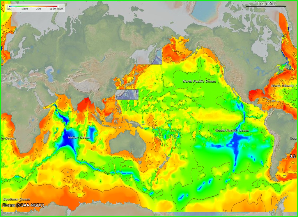
Released in the last few weeks, the EarthObserver mobile app lets you interact with geology, climate, underwater, sonar, atmospheric, etc. data once only available to earth scientists. There are three projections to choose from: Mercator, North Pole, and South Pole. Map resolution ranges from 4-30 meters, and an info button gives you access to data sources and citations. You can even take a screenshot within the app. EarthObserver was created by Columbia University’s Lamont-Doherty Earth Observatory, and looks absolutely amazing.

Ocean Sediment Thickness

http://www.earth-observer.org/

Unfortunately, I do not own an iPhone, iPad, or iPod. However, those of you who do can now access what appears to be a pretty darned cool app on your mobile device. The rest of us will have to settle for “companion software” on our Macs/PCs. I’m hoping an Android version will be available soon =). What are your thoughts?

GPSFiles to SHP – Now with ArcGIS 10!

Code base updated on 10/26/2010. Available at ESRI’s Code Gallery: http://resources.arcgis.com/gallery/file/geoprocessing/details/?entryID=BC061D5E-1422-2418-7FCE-CC0FBB0C0825

Issues:

  • ArcGIS 10 returns error: <type ‘exceptions.ImportError’>: Bad magic number…
  • GPX to SHP only processes the first track in the file

Changes:

  • gpsFile.pyc was not compiled in a manner compatible with ArcGIS 10. The file has been replaced with gpsFiles.py so that compiling can be done dynamically for both versions. The code continues to work as expected for Arc 9.3.x.
  • GPX to SHP now supports multiple tracks

Convert GPSFiles to SHP

ArcScripts is dead. Long live ArcScripts.

For my thesis, I needed to be able to convert either KML or GPX files to shapefiles in ArcGIS 9.3. Unfortunately, there was no inherent way to do so in Arc. Several months ago, I poked around ArcScripts (arcscripts.esri.com) and found a toolbox written by Jason Parent that would convert KML to SHP, but not GPX. After fiddling with his code for a while, I decided to rewrite the entire code base to parse XML programmatically, instead of piecemeal. Thus the first iteration of “Convert GPSFiles to SHP” ArcToolbox was born. I have since added PLT and WPT support as separate modules in the toolbox.

I went to upload the changes today, only to find out ArcScripts has been decommissioned, and ESRI now wants us to use “Code Gallery”. Unfortunately, I don’t care for the way ESRI organized the new site, but *shrug*, I can’t upload the changes in the old place, so what’s a girl to do? The new code can now be found under “Geoprocessing Model and Script Tool Gallery

I’m posting both links to my ArcToolbox here, in the case anyone need to convert the files from their GPS device to SHP. Updated code (supporting PLT, WPT, and including bug fixes), is available in the above mentioned Gallery at: http://resources.arcgis.com/gallery/file/geoprocessing/details?entryID=BC061D5E-1422-2418-7FCE-CC0FBB0C0825. Old code at ArcScripts is available at: http://arcscripts.esri.com/details.asp?dbid=16797.

The updated toolbox does NOT support ArcGIS 10 (I’m working on it).

Enjoy!

App Review: c:geo

I’ve recruited my 4-year old daughter to go “treasure hunting” (aka geocaching) with me. I’ve tried GeoBeagle before, with varying degrees of success. Usually I just get the cache info in GeoBeagle and input it as a waypoint in Maverick. Most recently I’ve been playing with c:geo, and find it to be much better (and cheaper. I’ll get to that later).

C:geo is more of a stand-alone application than GeoBeagle (or any other Android app I’ve tried). Like other geocaching apps, c:geo works with geocaching.com. Unlike GeoBeagle, you do not need a premium (ie: paid) geocaching.com account to download and store caches on your phone — c:geo will let you cache the locations directly. You can do this by inputting a geocode, lat/long, address, keyword, username, near you, live map (awesome feature), etc.

In addition c:geo can navigate you to the cache using Google Maps (great if you’re driving, as you get voice navigation as well), radar (have GPS Status installed), or compass. In a way, getting to the cache is almost too easy. And considering other accuracy validation I’ve done (which will be presented at the 33rd Applied Geography Conference in October 2010), I know the G1, and Droid Incredible, can navigate there within the apps’ reported accuracy.

Overall, if you’re looking for a really good, feature-packed, free geocaching app, I’d recommend c:geo. One caveat. I couldn’t manage to log in with c:geo until I re-downloaded and signed in with GeoBeagle. Only then would c:geo successfully log in. If you have a problem registering c:geo with geocaching.com, I suggest this work around. Happy caching!

Mobile Apps: Wikitude Drive Testers Wanted

When I first saw the demo for this app, it reminded me of orientation at Qualcomm. We had to get into groups and come up with a new product. The product my group (ie: I) came up with was glasses that would display your drive route directly in front of you, projecting your turn-by-turn navigation over the road. Wikitude World Browser comes close. The first AR satellite navigation system with global coverage, your driving directions are projected directly on top of live-video of the road before you.

The first 2,000 beta testers can get the app for free in the Android Market. I’ve downloaded it recently and will let you know what I think soon. Feel free to post your experience in the comments. QR Code provided for faster download.